
Feb. 2004 Lake Havasu from Six Mile Island to Topoch Gorge
Journeys of Sacagawea
|
Feb. 2004 Lake Havasu from Six Mile Island to Topoch Gorge |
| Date | 2/17/04 2/19/04 | Engine hours | 6.5 |
| Weather | Clear,50/60's | Fuel on board | 12 gal |
| Wind | light from the northwest | Fuel used | 6.1 gal |
| Water Conditions | lake level 450feet 53/56F | Miles traveled | 68 |
| Late February Sacagawea was fitted out for a short cruise up Lake Havasu following the old Colorado River bed to Topock. The average temperature during February is 70 degrees at Lake Havasu and the water temperature is about 55 degrees. It’s like having air conditioning in the desert. What could be better than a cruise under a clear blue sky and warm sun? | 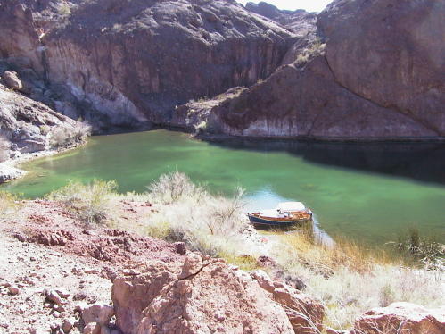 |
|
Launching at Six Mile Island (Lake Havasu City) Public boat ramp was free and a good starting point. Lake Havasu City is the central point of the lake. In 1957, Robert P. McCullooch was looking for a fresh water-testing site for his outboard motors engines. He was granted land with a provision for improvement and the growth soon caused him to move his testing to Los Angeles. Late in the afternoon of day one Sacagawea was loaded and cast off for London Bridge. Can you believe someone bought the original London Bridge and rebuilt it as the bridge to Six Mile Island? It has attracted a lot of tourist. After circumnavigating Six Mile Island I made a short run across from California Bay to a small cove for a night at anchor. The weather was calm and clear and a beautiful sunset across the lake developed. I dropped a 12-pound anchor off the stern and tied off the bow to a cedar root sticking out of the bank. It’s not a good idea to beach your boat overnight because the water level can change in just a few hours and you wake up with a land yacht. I always check the water level at the ramp before I depart. This time the water is at 450 feet. That is a good level and will make for good running upstream for Sacagawea, since she only needs about two feet to navigate. This really opens up the area you can explore on the river. I really like the way my Skiffamerica runs up on a beach, three feet of the boat on the sand and I can walk around with no tilting or rocking. Also getting off the boat is so easy with the lowered bow deck. The deck is a great place to leave your wet sandy shoes to dry without losing them. Steamboats also with flat bottoms like SkiffAmerica plied the river until the early 1900; using paddlewheels they supplied mining towns and other settlements along the Colorado River. Difficult rapids forced the crews to use iron ringbolts fastened to Giant rocks and cliffs by which the boats were winched upstream at some of the stronger rapids. The ringbolts can still be seen if you look hard as you past places like Blankenship Bend and Mohave Rock. Boat camping on the sandy beaches and side canyons is my favorite pastime in this area of the Colorado River in the winter. No crowds, cool temperatures and more animal activity then in the extreme heat of the summer days. I have seen bighorn sheep on the rocky ridges coming down for a drink. There are plenty of ducks, geese, herons, egrets, cormorants and pelicans to watch chasing their lunch. Golden eagles also fish the river. The second night I stayed behind a sandbar in a small cove with only two feet of water, it was a beautiful spot with a great view up and down the river. The next morning a boater came along and stopped on the sandbar and asked if I were aground because he had never seen a boat behind the sandbar with the water this low. Probably was not a good place to be if the water level went down more, but it would have come back up someday and there are worst places to be stuck in the sand, I guess I would just be forced to spend another night on this beautiful river.
|

|
Six Mile Island Launch Area |
 |
The is not what it is like in the summer when all the throngs of skiers and boats make it very crowded |
 |
Looking south as I was passing the west side of Six Mile Island |
 |
Approaching London Bridge from the North |
 |
Stopped for a bit of tea at London Bridge |
 |
|
| This is were the Colorado river opens into the main body of Lake Havasu, There are many sand and gravel bars as it runs into the main part of the lake. The channels shift and change in the area and water depth can change depth very quickly. Sacagawea was really at home in the shallow water and I had no problem with my shallow draft. | |
 |
Returned to small cove for first night on Six Mile Island |
 |
Mohave Rock from the south. You can still see iron rings from the early steamships that used it to anchor or help them upstream against the current the late 1800's |
 |
Stopped for lunch above Blankenship Bend. Hiked around looking for Indian paintings |
 |
Near Devil's Elbow the red and black rocks provide a dramatic backdrop to the blue/green water | ||
|
|||
 |
|||
 |
|||
 |
|||
|
Spent one night in this great cove behind Pulpit Rock The
channel to get in was 12 feet wide and 2 feet deep when I went in and the
next day it was 8 feet wide and 1 foot deep
Just made it over with engine up |
 |
The dock near Short's Camp were I had lunch on the second day. This is where I started back downstream. The trip back was 23.6 miles and I took 3.0 hours with a 3 to 5 knot current running with me. Just a slow pace to enjoy the scenery |
